Hurricane Nolo lashes Hawaii as new threat of 'volcanic hail' arises
Precursor activity has been detected at the Kilauea volcano, officials said.
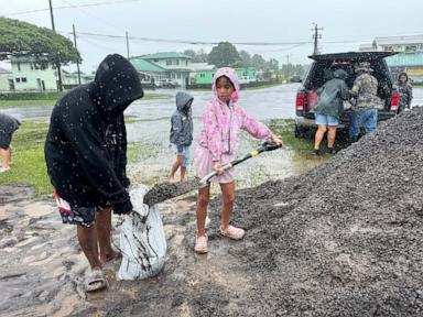
Millions of Hawaii residents are on alert for hazardous weather this weekend as Hurricane Nolo continues to swirl off the coast, bringing heavy rain and high winds to the Aloha State.
As of Sunday morning, Nolo was a Category 2 hurricane with winds up to 105 mph and was located south of the Big Island. Nolo's center is about 200 miles south of South Point, Hawaii, and is moving west at 9 mph.
People walk past a closed ticket counter for Southwest Airlines lined with sandbags at Hilo International Airport as Hurricane Nolo sits nearby, on Sept. 25, 2026, in Hilo, Hawaii.Gregory Bull/AP PhotoNolo briefly weakened on Saturday to a Category 1 hurricane but re-strengthened overnight to a Category 2 storm. It's expected to become an even stronger hurricane and make a westward turn, with the center staying well south of the Hawaiian Islands. Outer rain bands from Nolo will continue to lash parts of the Big Island and Maui on Sunday, but are expected to diminish in intensity later Sunday.
A flood watch remains in effect though Sunday night for the Big Island.
Latest Hurricane Nolo tracking forecast.ABC NewsDue to Nolo's weakening trend on Saturday, all tropical alerts for Hawaii have been cancelled. However, parts of Hawaii will continue to see gusty winds, heavy rain and large waves.
Alerts remain in place for parts of the Hawaiian Islands for gusty winds through 6 p.m. Sunday local time.
Hurricane Nolo is one of three hurricanes currently in the Pacific. Hurricane Polo remains a major hurricane Sunday morning, with maximum sustained winds of 120 mph making it a Category 3 hurricane.
Polo is forecast to impact parts of the Baja California Sur with tropical storm conditions as early as Sunday night or early Monday.
Hurricane Odalys is gradually weakening and barely remains a Category 1 hurricane, with maximum sustained winds of 75 mph. Odalys is expected to turn south and begin to dissipate later Sunday.
The last time there were three simultaneous hurricanes in the Pacific was when Kilo, Ignacio and Jimena formed in 2015.
As the Big Island continues to get slammed with rain and wind, officials expressed concern about the emergence of another possible phenomenon.
Hawaii County Mayor Kimo Alameda told ABC News that precursor activity has been detected at the Kilauea volcano, putting officials on high alert for the possibility of tephra -- or as he described it, volcanic hail.
ABC News"It could shoot as high as a thousand feet, right? And then if there is wind, then that wind pushes that tephra all over to the surrounding community," Alameda said. "If that tephra … got into our catchment tank, it impacts our water. So it messes up the catchment tanks, the swimming pools. The roads [have] got to be cleared because it's very dangerous if it's on our roads. So, it becomes to the threshold of a disaster."
Alameda said emergency officials are closely watching to see if the activity progresses, but he emphasized the last thing the state needs is to battle multiple disasters at once. Hawaii is still weary from four natural disasters in 2026 that will cost one billion dollars to recover from, according to Gov. Josh Green. Residents on the Big Island are still cleaning up debris from Hurricane Lala, which hit just six weeks ago.
"It's been rough, and we're doing the best we can in responding and trying to keep the spirits up for our residents," Alameda said. "But you know, it brings us together. I believe in every unfortunate situation there are many blessings, and so we look for those blessings, and that's what keeps us strong."
ABC News' Jaclyn Lee contributed to this report.