Satellite Images Show How Lake Powell Has Drained to Record Low in 9 Years
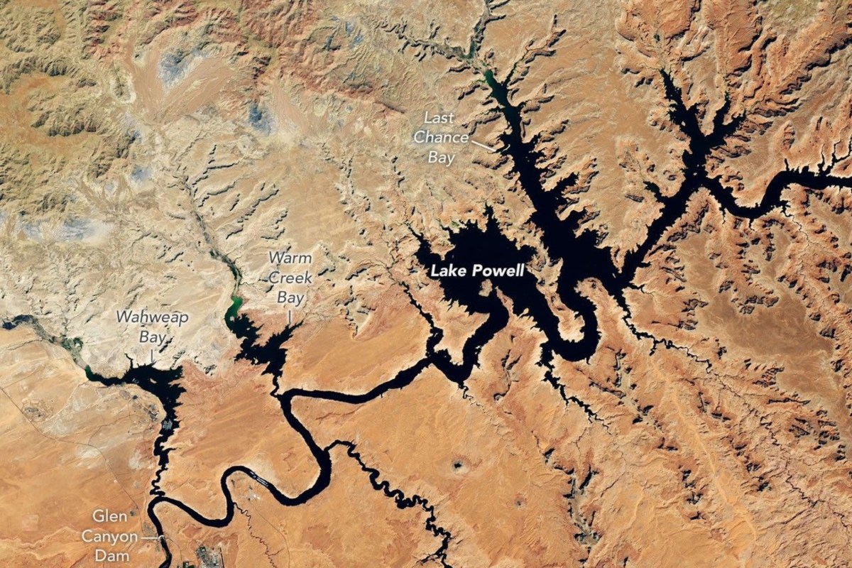
Newly released satellite images show the startling retreat of Lake Powell over nine years.
They compare the lake near Glen Canyon Dam on September 1, 2017, with the same area on September 10, 2026, and come after prolonged drought contributed to the reservoir reaching its lowest recorded level.
NASA described the reservoir’s 2017 level as one of its highest of the preceding decade. The second image, captured on September 10, 2026, showed substantially less water in the reservoir.
The agency said the 2026 image was captured as Lake Powell’s water level stood at 3,517.24 feet—roughly a month after its levels fell below the previous record low of 3,519.92 feet, which was set in April 2023.
Lake Powell, the second-largest reservoir in the U.S., sits along the drought-stricken Colorado River, which runs approximately 1,400 miles and supports seven states—Arizona, California, Colorado, Nevada, New Mexico, Utah and Wyoming—as well as Mexico.
The river provides municipal water for tens of millions while supporting hydropower, recreation, fish and wildlife, as well as millions of acres of agricultural land.
NASA’s release of the images comes after both Lake Powell and Lake Mead—the largest reservoir in the U.S.—hit record lows in August. The Bureau of Reclamation, which manages both reservoirs, said the new lows followed a record-low winter snowpack in the Colorado River Basin in 2025-2026.
Mead’s record low was “discouraging but not surprising," Sarah Porter, director of the Kyl Center for Water Policy at Arizona State University, told Newsweek previously.
"The reservoir will likely recover at least a little this winter, and with very heavy snowpack it could recover a lot, but levels at both Lake Mead and Lake Powell have ratcheted down over the last quarter century and one good winter won’t be enough to stabilize the system over the long term."
In April, federal water managers announced actions intended to help bolster falling water levels in Lake Powell, including the release of water from upstream Flaming Gorge Reservoir and a reduction in releases from Lake Powell downstream to Lake Mead.
The Bureau of Reclamation had warned that “without major intervention,” water level decline in Lake Powell could threaten hydropower production at Glen Canyon Dam.
New federal projections released earlier this week indicated that Lake Powell’s level could rise by some 40 feet over the next two years, though the same projection suggested Lake Mead’s could fall by a similar amount.
The Bureau of Reclamation’s September 2026 “most probable” 24-Month Study, under a scenario in which 6 million acre-feet of water is released from Lake Powell in the 2027 operating year, showed Lake Powell rising to 3,558.44 feet by June 2028. Lake Mead, on the other hand, could fall to 998.40 feet in August that year, according to the projections.
Contact Newsweek editor on this story: Edward Pearcey.